|
|
By Euan Kerr
Minnesota Public Radio
December 17, 2001
To most Americans, the Canadian border is something that has always just been there. It's a 4,000-mile line stretching from coast to coast, more clearly identified in some places than others. But historians will tell you the search for the border was far from easy. It took 60 years of exploration, negotiation and compromise to decide where the border ran. The debate over what was to become Minnesota's northern border was particularly contentious.
| |
|
|
|
||
The border between the United States and what was then British North America was established in the Treaty of Paris, signed in 1783. Or at least that was what the diplomats claimed. The problem was they used 30-year-old maps, to write a treaty referring to many places that didn't exist.
As the U.S. struggled with its new nationhood, working out the exact location of a boundary was a low priority. This was particularly true at what was then the western end of the boundary, running along Lake Superior and up to Lake of the Woods. European settlement was still sparse, limited to trappers and traders. So the border issue was set aside for 40 years.
Finally, in 1822, teams of surveyors went out to map the boundaries along Lake Superior and beyond. It was a long process, hampered by weather, distance, and the language of the treaty.
Francis Carroll, a senior scholar at the University of Manitoba, is author of A Good and Wise Measure, a new book about how the boundary was set. He told Mainstreet Radio's Euan Kerr there were several conflicting ideas of where the border lay west of Lake Superior.
Listen to part 1
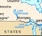
There were more disputes further west, which resulted in the creation of the Northwest Angle.
Listen to part 2
Even after three years of exploration and mapping, the U.S. and Britain could not settle the border location disputes. The issues again languished, this time for 20 years. It was not until 1842, when a change in the government in both countries resulted in various compromises, and the border was set.
The Pigeon River became the boundary on Lake Superior, which meant Duluth was a U.S. city, and what was to become known as the Iron Range also belonged to the U.S. Francis Carroll says some Canadians today feel they were ill-served by this decision.
Listen to part 3
More Information
Radio Listening : News & Features : Events Calendar : Your Voice : About Us