|
|
By Cara Hetland
Minnesota Public Radio
May 6, 2002
![]()
There's public debate over the management of many rivers in the U.S. Along the Missouri River, the hot topic is water level. But the fight is really about who should benefit from the way the U.S. Army Corps of Engineers manages the river. In states like Missouri and Kansas, navigation is important. But upstream, above some of the rivers' huge dams, recreation brings in millions.
| |||
| |
|
||
|
|||
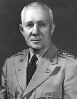
In December, 1944, President Franklin Roosevelt created a series of dams on the Missouri River. The project was designed to prevent flooding in cities like Omaha and St. Louis, and to generate electricity. The Pick-Sloan Project was named after its authors, two officers from the U.S. Army Corps of Engineers.
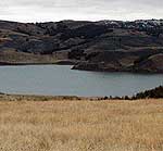
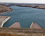
The Pick-Sloan plan turned America's longest river into the largest reservoir system in North America. There are six dams in three states, and four of them are in South Dakota. The dams turned the Missouri River into a series of lakes.
At the time, there were lots of promises. Major Gen. Lewis Pick told a crowd in the 1940s about all the benefits.
"We'll have enough water to irrigate approximately five million new acres of land. We'll have enough water to bring navigation on the Missouri River up to at least the first dam. And we will create in this great valley the greatest playground in America," Pick said at the time.
| |
|
|
|
||
That playground is the only promise that came true. Recreation is an $80 million industry in South Dakota.
However, generating support for the man-made lakes was a public relations nightmare. Entire towns were moved. Water flooded hundreds of thousands of acres of prime grazing land.
The promises included irrigation and drinking water projects for South Dakota. But there are only a few thousand acres irrigated with water from the Missouri. Many communities are just now seeing drinking water projects.
John Cooper heads the South Dakota Game, Fish, and Parks Department. He says once, the Missouri supported world-class walleye fishing. But now that industry is dying -because the river is dying.
"We can't just keep running this water in the same way we've been running it, basically since the Pick-Sloan plan was passed in 1944," Cooper says. "We know now that there are problems, and to turn our back on that and to not do anything is a disservice to the generations that are coming behind us."
Cooper blames the Army Corps of Engineers. He says low water in the reservoirs hurt the walleye and smelt spawning seasons. Low water also leaves a mucky sediment that keeps birds from nesting - all signs the river is unhealthy.
Cooper says the Corps needs to create a water flow that mimics nature. That means every three years in the spring, more water would be held back and then released quickly, flushing the river.
| |
|
|
|
||
Cooper says that would rejuvenate the life of the river. It would help bring back the Missouri that Lewis and Clark saw nearly 200 years ago.
"The one thing that remained throughout their records is...the ability of the dynamics of the river to recharge itself. And we've taken that away by putting these dams in here," Cooper says. "Yes, we've gotten a lot of benefits for our society, but we've substantially changed the health of this river. It's my firm belief that you can still have the hydroelectric power generation, the flood control issues, etc., if we can basically work through these alternatives to approximate the original flows."
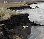
That natural flow could help Native American tribes with reservation land along the Missouri. They're losing thousands of acres every year to erosion, because constant wave action presses the river into a wider and wider stream.
"As a result of erosion the picnic shelters...have been washed into the river. We have one remaining out of four. The beach is no longer a beach - it's a four to six-foot cut bank," says Scott Jones, spokesman for the Lower Brule Sioux Tribe.
| |
|
|
|
||

This area is about a half mile from the town of Lower Brule. It's a prime tribal gathering spot. The reservation has land along 80 miles of the river's west bank. It's in an area known as Big Bend - where the river twists. Lewis and Clark crossed here, and called it The Narrows.
Scott Jones says the riverbank is falling in and uncovering bones and other artifacts. Jones says they also see remains when the Army Corps lowers the water levels.
"There were skulls sitting on the mud flats down at the fort hill bottom. We have a very difficult time dealing with that," says Jones. "The mud is so gummy and difficult to get across. We were put in the position of not being able to deal with one particular ancestor, whose skull was sitting on top of the mud flats."
Jones says his tribe needs to protect sacred burial sites, and protect the banks from looters. Many people rob the sites. It's illegal, but with thousands of miles of river banks, there's no way to police looters.
The Lower Brule Sioux Tribe wants help from the National Trust for Historic Preservation. The tribe wants more than 1,500 miles of the Missouri River in South Dakota, North Dakota and Montana named to a list of endangered historic places. Scott Jones says it's one way to force historic preservation along the river.
| |
|
|
|
||
The Army Corps will release its new rules for regulating water flow at the end of the month. There is speculation the change will benefit recreation states like South Dakota, North Dakota and Montana. Corps spokesman Paul Johnston says the decision is all about balancing competing interests.
"For every change or nuance of change, there is a constituency for and against. There are some perceived environmental benefits for doing one thing, there are costs for doing that," Johnston says. "The low summer flow for example - we know it would create some additional low-lying sand, and that's the kind of nesting habitat the terns and the plovers like. But we know also if that's going to happen we would generate less hydropower."
Issues like those put the U.S. Army Corps of Engineers in the hot seat. And there are other groups weighing in. American Rivers has named the Missouri as the most endangered river in the country. The group says the Corps should change the flow of the river to restore it.
For the past 50 years, the corps maintained water levels for navigation in the downstream states of Iowa, Nebraska, Kansas and Missouri. Some say the corps is supporting an $8 million barge industry at the expense of the river. The U.S. Fish and Wildlife Service wants more focus placed on the health of the river, warning that action is needed soon.
But the river itself may force everyone's hand. The increase in sediment, raising the river bottom, may soon cause flooding. It's possible then that mother nature will return the Missouri to the wild, free-flowing river it once was.
More InformationRadio Listening : News & Features : Events Calendar : Your Voice : About Us