|
|
|
Photos
Resources
Your Voice
|
Group wants 90,000 acres protected near BWCA
June 12, 2003
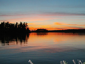 |
| Big Lake is one of the areas recommended for increased protection. (Photo courtesy of Friends of the Boundary Waters Wilderness) |
St. Paul, Minn. — Outside of the Boundary Waters Canoe Area Wilderness, or BWCA, the Superior National Forest is heavily roaded. But in some places, those roads have fallen into disuse, and beyond them lie pockets of wild land.
Volunteers looked for scenic and ecologically diverse spots far from roads and other signs of human disturbance.
 | |||
Andy Holdsworth, a Ph.D., candidate in conservation biology at the University of Minnesota, helped train some 50 volunteers who collected data and photographs.
"We would drive just the gravel roads and then when vehicles had not passed, we would get out on foot and then walk to the end of often a grassy track," he says. "So we would simply be walking this routes, sometimes a few miles into a unit, and it was obvious over the last several decades, trees were regrowing in them, and sometimes the road would stop miles before the map said, or it would just be impassable."
Many of the places volunteers explored were "roadless areas" that were identified in a national wilderness survey in the 1970s. In some cases, those areas had later been disturbed by logging, roadbuilding, or other activities.
But this most recent survey also found 24 parcels that were seemingly untouched, or had reverted to wilderness. Many are adjacent to the BWCA.
 | |||
Friends of the Boundary Waters Wilderness policy director Sarah Strommen said the parcels could offer hiking trails, and a few could be used to expand the existing canoe and portage routes in the BWCA. She says one example is the Agassa Lake Unit, a 2,300-acre parcel adjacent to the Trout Lake Unit of the BWCA.
"According to maps from the 1960s, there was once a portage between Slim Lake and Big Lake. If this portage were rebuilt through the Agassa Lake Unit, it would create a nice canoe route that included Big Lake, Lapond Lake, Big Rice Lake, Hook Lake, Rice Lake, and Slim Lake," according to Strommen.
Supporters of adding more land to the million-acre BWCA point out that it's the most heavily used wilderness in the nation. The U.S. Forest Service's most recent plan calls for managing many of the 90,000 acres identified by the Friends for "general" use. That means logging, mining, and ATV trails could be permitted.
The group is asking the Forest Service to recommend the areas to Congress for wilderness status. Congress must approve any wilderness designations.
 | |||
Superior National Forest Supervisor Jim Sanders says the agency welcomes public involvement as it continues its planning process.
"They're providing the the type of information we need and that's substantive comment to our draft environmental impact statement where we considered seven alternatives that looked at a number of factors including wilderness potential across the forest."
The Forest Service's draft plan designates no new wilderness for the Superior but Sanders says that decision is not final. He says it will be 9 to 12 months before the agency finishes its plan.
Respond to this story
|
News Headlines
|
Related Subjects
|
Radio Listening : News & Features : Events Calendar : Your Voice : About Us