|
|
|
Audio
Photos
Resources
Your Voice
|
America's biggest real estate deal included half of Minnesota
July 4, 2003
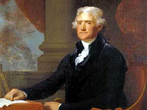 |
| President Thomas Jefferson completed the Louisiana Purchase in 1803, buying more than 800,000 square miles from France. (Gilbert Stuart's Portrait of Thomas Jefferson 1805-1807, Bowdoin College Museum of Art, Brunswick, Maine) |
St. Paul, Minn. — The Louisiana Purchase happened in part, Virginia-based historian Jon Kukla says, because Napoleon Bonaparte needed money to lead France into war.
On this side of the Atlantic, Kukla says, President Thomas Jefferson was worried Spain was going to choke off America's river traffic in an area it controlled near the mouth of the Mississippi River.
The only way around the threat, Kukla says, was for the United States to convince France to sell land that included what is now New Orleans.
 | |||
"The original object was simply to acquire New Orleans and west Florida," Kukla says, "to open the navigation of the Mississippi, and therefore make it possible for the farmers in the trans-Appalachian west -- which is to say Kentucky, Tennessee and that area -- to get their produce downstream."
Kukla's book, A Wilderness So Immense: The Louisiana Purchase and the Destiny of America, describes the controversy surrounding the real estate deal. President Thomas Jefferson told U.S. diplomats in Paris to pay no more than $10 million.
Kukla recalls the words of one Congressional opponent convinced it was no time for a fledgling country to be buying property.
"He said, 'We are about to acquire land, of which we have enough, with money of which we don't have enough,'" says Kukla.
 | |||
Over in Paris, the American negotiators were offered a much sweeter deal than expected. How would they like to buy the whole territory -- hundreds of thousands of square miles stretching west from the Mississippi across the mid-section of the North American continent -- for about $15 million?
Kukla says Napoleon's new terms grew out of his need to raise cash.
"He wanted to go back to war against Great Britain and he wanted the money," Kukla says. "So selling Louisiana to the United States for $15 million worked out on a whole bunch of different scores. And within weeks he was back at war with Great Britain."
Kukla says Napoleon was also eager to sell because his scheme to create a sugar empire in Haiti had gone sour. He wanted the Louisiana territory to supply food for the slaves harvesting the sugar. However, the French troops sent to Haiti by Napoleon were decimated by a slave revolt and fever, and Napoleon had lost his taste for the venture.
|
Let the land rejoice, for you have bought Louisiana for a song.
- Gen. Horatio Gates, to President Jefferson |
When the deal was finally inked in May, 1803, the United States owned 828,000 square miles of land mostly unseen by white people. And, of course, the native people whose ancestors had been living in the area for centuries were not consulted.
Setting aside the genocidal effect of the Indian wars that were to follow, historian Jon Kukla argues buying a chunk of land as big as the Louisiana Purchase probably helped the U.S. avoid more fighting with Mexico and Canada.
"North America wasn't cut up into a whole bunch of smaller states, and that therefore the history of North America was perhaps more peaceful than it might otherwise have been," Kukla says. "We think of ourselves as a peaceful people, but we've got two neighbors and we've fought both of them in the war of 1812 and in the Mexican War."
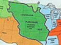
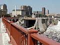
The Louisiana Purchase is easy to visualize if you visit downtown Minneapolis.
Standing on the Stone Arch bridge over the Mississippi looking upriver, the Louisiana Purchase is on the left from downtown Minneapolis west to Montana. It includes all or parts of what are now 15 states. The British claimed control of the right or east bank of the Mississippi, all the way to the river's headwaters in northern Minnesota.
 | |||
Alan Woolworth, emeritus research fellow at the Minnesota Historical Society, says British royalty handed out land grants for fur trading. Winning a royal grant for the British-sponsored fur trade was one thing. Backing it up, Woolworth says, was another.
"Basically, those grants meant that you had the backing of the French or British government to go there, and to try seize the territory and use it for your own purposes as best you could," says Woolworth.
His superiors sent Zebulon Pike, a young Army officer, north from St. Louis to what would become Minnesota with orders to chase the British out.
Pike was not very successful.
He ended up relying on British hospitality to see him through a tough winter. Pike's limited claim to historical fame was buying land from Indians that would become Fort Snelling.
 | |||
It is more than a historical footnote to ask why the European superpowers believed they had the right to claim and invade lands they'd never seen. Alan Woolworth traces the power mongering to the Roman Empire.
"It dates back to almost Roman times, where in theory at least, a so-called civilized nation had pre-eminent rights to go into the lands of some other country or group of people or tribal territory, and seize it," Woolworth says.
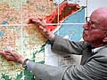
The observance of the Louisiana Purchase bicentennial has not set off the same travel frenzy created by Americans interested in retracing the route 200 years ago of Lewis and Clark. However, Minneapolis photographer Stuart Klipper says there are plenty of visual rewards awaiting visitors to the 15 states that grew out of the land deal.
Klipper is observing the anniversary by showing 15 panoramic images, one from each state, in an exhibit at Groveland Gallery in Minneapolis. One of his favorites is of a long, low butte at sunset in western Nebraska.
"You can start wanting to breathe that air and hear the bird calls in the evening," Klipper says.
 | |||
Another is of a bridge that leads to Hermann, Missouri, the river town settled by Germans.
"It was a pristine brick town and I just marvelled at it," Klipper says. "I told the motel guy they did an amazing job of restoration, and he said, 'What are you talking about? These are Germans. It's always been like this.' You do not need the National Trust for Historic Preservation in certain parts of country."
Photographer Stuart Klipper's images at the Groveland Gallery in Minneapolis are a contemporary view of the Louisiana Purchase. All of them remind viewers of the vastness of the territory and how its acquisition shaped the United States. The show continues through July 26 before moving on to Des Moines.
Respond to this story
|
News Headlines
|
Related Subjects
|
Radio Listening : News & Features : Events Calendar : Your Voice : About Us