Site Navigation


|
Photos
More from MPR
Resources
|
February 7, 2005
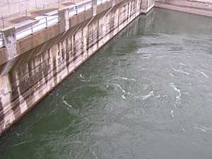 |
| The amount of water released along the Missouri River is controlled by the U.S. Army Corps of Engineers at the power plant at Gavins Point Dam. (MPR Photo/Cara Hetland) |
Sioux Falls, S.D. — It's a plan designed to prevent a crisis. The upper Missouri River basin is in the fifth year of a drought. Spring and summer rains have been below normal, and winter snowfall has also been way down -- meaning no big spring runoff. Gov. Rounds says if water isn't conserved now, downstream states will see rolling electrical blackouts, and commercial barge traffic could come to a halt.
Gavins Point Dam, about 60 miles south of Sioux Falls, is one of the six dams along the Missouri River. But Gavins Point is key, because it controls the levels downstream for power production and navigation.

The water here drops 50 feet through a turbine and creates electricity. The amount of water that drops depends on how much is released. The Army Corps of Engineers controls the spigot and decides how much to release, based on the depth of the river.
The Missouri River is already at record lows. But if the river drops another four feet, the corps will be forced to release the bare minimum from Gavins Point Dam. It'll shut down navigation and cripple power generation. That bare minimum is a magic number of sorts -- 18,000 cubic feet per second (cfs). It's a level many downstream have never seen before. Dave Becker, power plant manager at Gavins Point, describes what 18,000 cfs might look like.
"Imagine you're up in the stands watching a football game on a Friday night," says Becker. "If there were six inches of water put on that field in a second, that's pretty close to what 18,000 cfs of water is."
It may seem like a lot of water, but there are six hydropower plants along the Missouri River and that amount of water isn't enough for them to operate at full capacity. Those six plants generate electricity for 58 communities in four states. Residents from Worthington to Moorhead are seeing an increase in their power bills, because hydropower production is already down 35 percent.
Current water levels on the Missouri River have forced the utilities to purchase power off the open market to make up the difference. Bill Radio, spokesman for the Missouri River Energy Services, says rates went up 20 percent in 2004.
"We already know that there will be another rate increase of at least that much by the end of this year -- the beginning of 2006," says Radio. "So that's a pretty substantial amount of increased cost in a two to three-year period of time."
The swirling waters of the Missouri River don't just generate hydropower. Coal-fired plants rely on the river for cooling water. There are 18 power plants in four downstream states, and their intake pumps are not designed for low river flows. Even though many power plants have spent millions to modify their system, none are set low enough for that magic number of 18,000 cfs.
Professor John Kruse of the University of Missouri Food and Agricultural Policy Research Institute, says water temperature is also a concern. When river levels are low, the water is naturally warmer.
The EPA regulates discharge temperatures. Most plants cannot discharge water warmer than 110 degrees. Many power plants don't have cooling ponds and can't use the water if it's that warm.
Kruse created an historical model of river flows and power production during peak summer months. He says at that magic number of 18,000 cfs, power plants were forced to shut down one-third of the time. Kruse says that's a conservative estimate.
The answer, according to many, is for utilities to buy power off the grid. But John Kruse says if all the plants up and down the river are in the same boat, that answer may have a shocking price.
"They kind of look at things in a vacuum and say, 'Well, if nobody else is, this is how much we can move around.' If you start to talk with them that if they couldn't buy from another reliability region because it was already being sourced for this purpose, they'll look at you and say, 'We've always assumed we could buy unlimited power from other regions,'" says Kruse.
Kruse says in order to guarantee power, there has to be a higher release out of Gavins Point Dam in the summer months.
Not everyone agrees that minimum water releases would create rolling blackouts. Paul Johnston, spokesman for the U.S. Army Corps of Engineers, says the corps has to follow the rules laid out in its management document called the Master Manual.
"We've made a commitment to the people of the basin (about water levels) that we're not going to make a change to the Master Manual without a very public process. The last time we had a public process on a significant change, it took 14 years," says Johnston. "So I think for the near term we'll probably stick with the plan that's already out there."

After all, Johnston says, it just might rain. The commander of the Army Corps of Engineers attended the governor's summit to listen to arguments calling for conservation and a change in how much water the dams release. But he made no guarantee it would happen.
Water experts in South Dakota disagree with the corps' position. Garland Erbelee, water specialist with the South Dakota Department of Environment and Natural Resources, says water levels in the Missouri River basin are at an all-time record low. He says it's important to conserve water before it runs out.
South Dakota has sued the Army Corps over it's management of the river several times. Each time a judge has ruled that the Master Manual is only a guide for the corps for follow.
"We believe that the corps has a certain amount of latitude within the Master Manual to make the operational changes. We also believe -- and this is the governor's effort here to bring the basin governors together for a summit -- that if we get all of the states in agreement with us, that there is enough reason to conserve additional water this year that the corps has the ability to do that," says Erbelee.
South Dakota Gov. Mike Rounds has put together a plan to conserve water. He wants the Missouri River dams to release less water this year, and delay the start of downstream navigation by one month. Rounds says it's a way to ensure water next year. The summit is also an attempt to avoid future lawsuits.
The governors from Nebraska, Missouri, North Dakota, Montana and Wyoming attended the summit. Rounds says the argument over Missouri River water levels has become larger than the fight between recreation and navigation interests. Now, it's about finding a way to keep the lights on.
|
|