Site Navigation


|
Photos
Resources
|
August 25, 2005
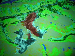 |
| Wearing special glasses you can see the 3-D effect of a new generation of satellite maps. The glasses help bring the detail of ground vegetation to life. Thick trees stand out as a dark green. Lighter green shows bushes or grass. (MPR Photo/Cara Hetland) |
Sioux Falls, S.D. — There's a big screen on the wall with a huge view from space. Varying shades of green tell you you're probably looking at mountainous landscape, but it takes special glasses to enhance the 3-D effect and the colors.
They look just like black-framed aviator glasses. Put them on, and suddenly the satellite view of a mountain region springs into detail. Thick trees are a dark green. Lighter green shows a valley or bushes or grass. A large blob of grey is the remnant of a fire. The computer can zoom into an area smaller than a swimming pool.
Henry Bastian, director of this imaging project for the U.S. Department of the Interior, says when he looks at the map, he sees a formula for a forest fire. It's a map that can tell firefighters more than just what the land looks like ... it'll tell them where the fire might go.
"It's also going to provide kind of the height the depth of the fuels, (for example) the heights of your trees the cover of those trees the cover of the shrubs, the grass lands," says Bastian.
A computer can use these maps to simulate fires. Bastian says the program coordinates where a fire starts with current weather conditions and then predicts what may happen. That information has many uses. It can help fire fighters, homeowners and even insurance companies determine fire risks.
Dan Crittenden works on the mapping project for the U.S Forest Service. He points to a satellite map of Rapid City, South Dakota.
"If you look at this, you can see how Rapid City is now expanding out into the wild lands. Here's a community right here, another one right in here," says Crittenden.
He says simulating a fire for the area could help local residents develop an evacuation plan. They'll know how the things around them will burn and in which direction.
"We could tell you what kind of time you might have to evacuate that area," Crittenden says. "You could decide how to treat the fuels around there to increase your time or you might want to develop a strategy that says we'll shelter in place. It gives communities an opportunity to model extreme fire danger and plan accordingly." Crittenden says the maps are also a tool for communities to decide what kind of fire risk they're willing to live with and how that risk changes if you clear out certain areas.
"We can show you if you leave these trees in their current position standing and we run a fire through there, it will tell you the rate it spreads, the intensities, your resistances to control and how far that thing will go under certain conditions. If you harvest that area and we remodel that same thing we can show you how it will react based on land-fire data too," he says.
Crittenden says the simulation map can eliminate high fire danger areas during peak season. He says during the summer months, it'll be an invaluable tool to fire analysts.
Jim Strain, Chief Fire Management Officer in the Black Hills of South Dakota says he's heard rumors about such a map but didn't know many of the details. He says it'll be a handy tool but one that won't be used when a fire is first spotted.
"Fire managers don't have the time at time to really sit down in front of a lap top to tap out some stuff to get some input you just have to fly just right off the seat of your pants as to what they know for local knowledge to get people out of the way," says Strain.
Strain says fire analysts will use the information from a simulation within 48 hours after the fire starts. That's when they have time to decide the best way to attack a wildfire.
It'll take about three years to complete the maps. Congress appropriated a billion dollars for the project. The western United States will be completed first and then states to the east.
|
|