|
|
By William Wilcoxen
Minnesota Public Radio
May 6, 2002
![]()
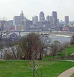
Most of our region's biggest cities are located on waterways. Residents have relied on rivers for drinking water, transportation, and industrial power. We've modified rivers with dredging, dikes, and dams to meet our needs. But those changes are coming under scrutiny as we learn more about their impact.
| |||
| |
|
||
|
|||
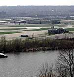
Spring is in the air along St. Paul's Mississippi riverfront, and this spring planes are in the air, too. They're flying into the city's downtown airport, Holman Field, which sits on 500 acres along the Mississippi River.
A year ago, the river spread out over its flood plain, and beavers outnumbered Cessnas on the runways. Gary Schmidt, who works at the Metropolitan Airports Commission, says Holman is normally the busiest of the reliever airports. It gives corporate planes easy access to the Twin Cities. That's why it attracts many small planes away from Twin Cities International. But last year, Holman Field was underwater for months.
"And it was a big inconvenience, and probably a fairly good expense for some of our operators here who had to relocate to other airports," says Schmidt. "And, for the most part, the only airport they could utilize was the Minneapolis airport. And that's exactly what this airport is trying to accomplish - to attract that type of traffic away from there. So, we were defeating our own purpose once we had the flood down here."
St. Paul business leaders say a convenient downtown airport is a selling point in recruiting new companies to the city. The Chamber of Commerce reports the shutdown last year has some businesses reconsidering their reliance on Holman Field.
That's one reason Mayor Randy Kelly is pushing for construction of a flood wall, to protect the airport from high water.
| |
|
|
|
||
"If you're going to have an airport, it's going to have to be something that's open and accessible year round," says the mayor's top aide, Dennis Flaherty. "That airport was underwater for I think over three months. And that's just totally unacceptable."
St. Paul business people generally favor the flood wall. Environmental groups are less enthusiastic.
"Ecological damage happens very incrementally. And this is a great example of an important increment that is kind of tied to a much bigger problem," says Whitney Clark, who directs Friends of the Mississippi River.
Changes to the river send ripples through the natural life the Mississippi sustains. But people have been molding the Upper Mississippi for more than 150 years.
Historian John Anfinson of the National Park Service says the first major change dates to 1866. That's when Congress authorized the Army Corps of Engineers to maintain a four-foot shipping channel.
"It was going to try to maintain a channel that was four feet deep, all the way from St. Paul to St. Louis," Anfinson says. "Until then, the average depth at low water of the river between St. Paul and Hastings could be 12 to 18 inches. So you could literally walk across the river up to your knees most years."
To make a narrower, deeper channel, engineers removed dozens of Mississippi River islands. They were dredged, or connected to the shore with fill. Now, the Corps maintains a nine-foot channel using a series of locks and dams. They divide the river into segments and prevent water levels from dropping too low. A predictable flow makes the river reliable for transportation.
But park ranger Dave Wiggins says that kind of dependability is not in the river's nature. Wiggins is on the staff of the Mississippi National River and Recreation Area. He says in its natural state, the river would not only rise and fall, but move from side to side as well.
"The river wants to wiggle around. A river meanders and its natural life is a very active, wiggly snake," says Wiggins. "It doesn't like to stick in one course in a landscape like this. In its history, the river has cut all sorts of new channels, even through the Twin Cities area."
| |
|
|
|
||
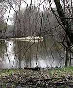
Wiggins says natural rivers usually have poorly-defined banks. Marshy backwaters create a gradual transition between land and water. Those transition zones are especially rich with plant and animal life. On a visit to Riverside Park a few miles downstream from St. Paul, two mallards watch from a distance as Wiggins points out the animal habitat in a stagnant backwater.
"There's plenty of nice mud in here for the turtles and frogs to use over winter. This is a terrific edge here. You've got tangled branches under the water, and great fish habitat in through here, and a combination of still waters and moving waters. Whatever a creature might require, you could find it in here," says Wiggins.
Swampy backwaters are relatively rare in urban settings. Civilization seems to prefer clear boundaries separating the land from the water. That kind of certainty allows the propellers of commerce to keep turning.
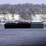
Take the barge industry, for example. It will move 20 million tons of cargo on the Upper Mississippi this year. Rafts of barges are pushed by towboats.
Commercial navigation provided the impetus for the lock and dam system more than 60 years ago. Commercial traffic remains the river's biggest user. But the changes commercial activity brought to the Mississippi are now part of the daily lives of many Midwesterners. Dennis Erickson, navigation manager for the Army Corps of Engineers, says more pleasure boats are passing through the locks.
| |
|
|
|
||
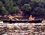
"We've seen an increase in recreational boats. At our 13 locks here in the St. Paul district, we probably get (more than) 120,000 recreational craft per year through all of them," Erickson says.
Companies doing business on the waterfront get a first-hand view of the variety of river users. Lee Nelson is president of Upper River Services, a St. Paul company that cleans, repairs, and stores barges. Nelson says many people enjoy the river as its been modified by the locks and dams.
"During hot summers, when the river used to go down to no more than a foot and a half deep - and was more similar to what we'd call a creek than a river - we may not have the aesthetic value that restaurants and hotels, and potentially ballparks and theatres, and a science museum have come to appreciate and want to be a part of."
Cities like St. Paul have evolved around a river altered by humans. But some people say cities should plan for a future that respects the natural pulse of the river and accommodates its moods. That's Whitney Clark's perspective.
| |
|
|
|
||
"The forward way of designing our cities around the landscape and around rivers is not to irrevocably alter the landscape that we're trying to embrace. But rather, to see if we can't take steps to develop more in harmony with that function," says Clark.
Last year, soggy runways kept some planes away from Holman Field until September. That's too long for many businesses. The Airports Commission is working with the Corps of Engineers and Minnesota's Department of Natural Resources to study the effect of an airport dike. That study may be finished this summer.
But the commission will still need to conduct an environmental impact statement, and gain approval from several other agencies, before anything is built. The Park Service's John Anfinson says - no matter what happens at the airport - it's good that people are talking about what the urban Mississippi should be.
"It's an issue that a lot of people are going to question. 'Why is it needed? What do we lose? What do we gain?' I think there's going to be a debate over how that takes place in the future," says Anfinson. "I think there's already debates about how that takes place, and I think that's the healthiest thing we can have. We can explore what is the the value of this place to society, for the different purposes it serves."
Airport officials say it will take at least two years to gain approval for a flood wall around Holman Field.
More from MPRMore Information
Radio Listening : News & Features : Events Calendar : Your Voice : About Us